|
|
|
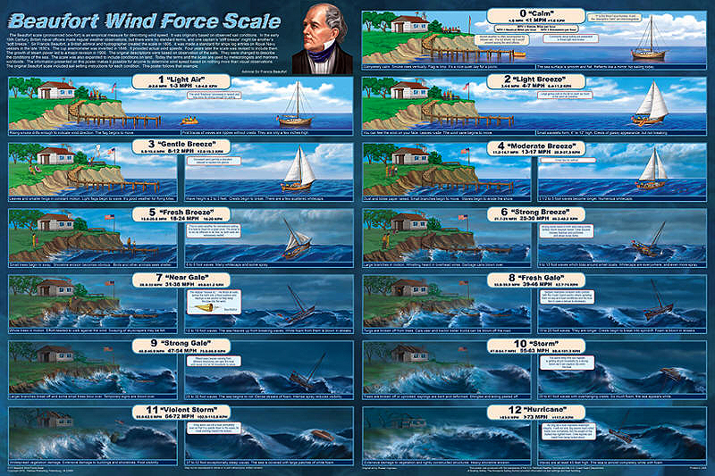
Beaufort Wind Force Scale |
|
 |
|
B493 Beaufort Wind Force Scale
The
Beaufort scale (pronounced bow fort) is an empirical
measure for describing wind speed. The terms it defines
are used by meteorologists worldwide. Force 0 is calm,
no wind. From there, it describes the various breezes,
gales and storms, culminating in the Force 12 hurricane,
which has winds of 75 mph or more.
Admiral Sir
Francis Beaufort was a hydrographer and top
administrator in the British Navy. Sea captains used
different terms to describe wind conditions, so, in
1805, Beaufort established a standard scale. It was
originally based on observations of how the wind
affected the sails on a ship. The Royal Navy required
that the terms be used for ship log entries. The
invention of the cup anemometer in 1846 resulted in the
Beaufort Scale being expanded to include actual wind
speeds. Years later, the steam engine ushered in the
demise of sailing ships, so sea conditions were
substituted for sail conditions. The scale was later
expanded to show conditions on land.
Admiral Beaufort’s original scale included sail
setting guidelines, so we followed his example using a
40 foot sloop. Insets suggest sail settings and boat
handling recommendations for each force. They also
include safety recommendations.
This poster cites the official description of each
wind force, but goes beyond that to show how it impacts
both land and sea. The dramatic illustrations show
increasingly powerful winds and waves systemically
destroying a summer beach cottage and tearing off large
sections of the cliff, severely eroding the shoreline.
The terrifying sea conditions really put the little
sloop in harm’s way.
Knowledge of these visual standards makes it possible
for anyone to determine wind speed based solely on
observation, just like the master mariners of
yesteryear. This is the first time that this important
information has ever been presented in such detail in
any media. It is an essential reference chart for
meteorologists, seamen or anyone else who wants or needs
to know how to identify weather conditions
|
|
|